Earth Observation Satellites have been orbiting our planet for decades now. Being human eyes in space, they enable an array of possibilities never available before, including monitoring climate change and locating and tracking the effects of human-made and natural disasters. But a special domain that satellites cater to is agriculture.
With the need to produce food for a constantly growing world population, farmers cannot rely solely on traditional methods anymore. Precision and smart use of resources are a necessity for those who want to achieve high yields while minimizing production costs. Satellites are one of the best allies in this endeavor.
Backed up with modern AI technologies, they help create a crop type map, track crop health, plan field activities, apply water and fertilizers wisely, estimate crop yield and much more. All of that wouldn’t be possible without precision. So, before we get into more detail on what satellite data has to offer, let’s see what exactly precision means in farming and why it’s so important.
Table of Contents
The Power of Precision
Precision agriculture is revolutionizing farming with the help of different technologies, satellite imagery analytics being on top of the list. For example, crop identification using remote sensing allows farmers to plan crop rotation, have a look at what goes on the market, manage land based on crop type, and more.
More so, satellite data helps in detecting the most subtle variations in plant conditions across different parts of a farm. Armed with this information, farmers are able to create detailed zoning maps, which indicate the varied needs of crops at different plots. This precise identification allows for tailored applications of water, pesticides, and fertilizers, leading to more efficient use of resources, cost reductions, and minimal environmental impact.
All in all, the increasing reliance on satellite imaging in precision agriculture is driven by the goal of enhancing crop productivity and streamlining farm management processes. Satellite data is crucial for continuous monitoring of crop health, identifying areas in need of intervention, and facilitating targeted treatment strategies.
Employing such data-driven insights, growers can significantly boost their crop yields, reduce operational costs, and improve sustainability. Moreover, the availability of user-friendly analytics platforms and satellite data services has made it easier for farmers to access, analyze, and integrate these insights into broader agricultural practices.
Data-based Predictions: How They Work
Predictions and forecasting are primarily conducted using machine learning algorithms. These algorithms, particularly neural networks, integrate satellite data and on-farm sensor data on soil and plant conditions to make predictions. AI enhances satellite monitoring in several areas, including yield and disease forecasting, irrigation needs, identifying high-yield soil areas, trend prediction, optimized harvesting routes, and profit estimation.
More so, having predictions makes it possible to assess crop bio-productivity levels, determining which crops have the highest biomass of reproductive organs, and thereby guide future planting towards more profitable crops.
Soil and Crop Analysis
Satellite data analytics offers unmatched insights into crop and soil health. It empowers farmers with accurate, up-to-date information, enhancing crop management and promoting healthier, more productive soils. Let’s see what can actually be done with crop and soil data collected by spacecraft.
Crop Identification
Crop classification using remote sensing has become an invaluable tool in modern agriculture, leveraging satellite imagery to accurately identify and differentiate various types of crops. This method implies the analysis of spectral signatures specific to different crop species to enable precise categorization.
The ability to remotely identify the type of crop grown in a given area provides crucial data for agricultural planning, resource management, and yield prediction. This technology not only improves the efficiency of crop monitoring on a large scale but also supports sustainable farming practices by offering detailed insights into crop health and land use.
Moisture Monitoring
Although water is essential for plant growth, it can be a disruptive force if applied recklessly. To avoid that, it’s critical to keep track of both soil and plant moisture. Soil moisture maps combined with other data help improve agricultural practices, including crop planting, yield forecasting, and monitoring of droughts and floods.
These maps identify areas unsuitable for planting due to extreme soil conditions. Precision irrigation, guided by these insights, reduces water and energy costs and minimizes crop stress. Long-term soil moisture data also aid in predicting and mitigating climate change impacts.
More so, satellite data analytics based on moisture indices data provide detailed information on crop water needs at different stages, enabling more efficient irrigation and water conservation.
Crop Monitoring and Management
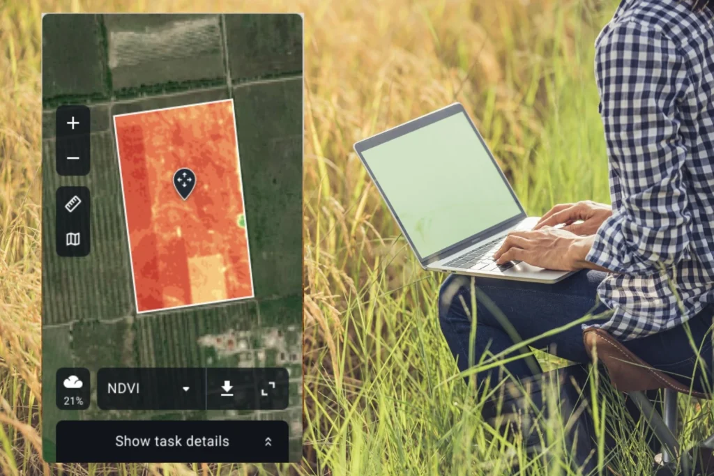
Remote sensing not only offers images of Earth but also enables scanning of its surface in spectrums beyond human vision. This technology is pivotal for crop health monitoring and management. For instance, vegetation indices like the Normalized Difference Vegetation Index (NDVI) help indicate plant health at different development stages, warning about moisture deficiency or diseases, enabling farmers to make informed decisions.
Yield prediction and harvest optimization
Modern farmers use satellite imagery, soil sensors, and meteorological data for precise crop yield forecasts, enhancing logistics and market planning. Technological advances have also revolutionized harvest timing. Growers now rely on spectral analysis for accurate crop maturity assessments rather than subjective field evaluations.
The advent of robotic technology for harvest readiness marks a blend of innovation and tradition in agriculture. This shift towards advanced agri-tech not only boosts efficiency but also promotes sustainability, balancing productivity with environmental protection.
Although it seems satellite analytics have already revolutionized agriculture on a global scale, challenges like data access and affordability for small-scale farmers are still here. Fortunately, continuous advancements in satellite technology aim to resolve these issues. As satellite technology advances, it promises to further sustainable farming and greater agricultural resilience, contributing to a more secure future in global food production.